Heavy rain & Low level jet
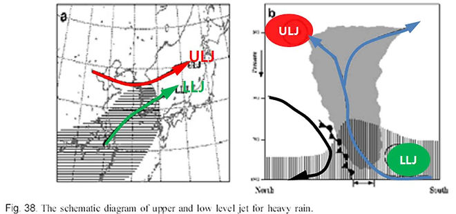
This picture is Vertical and horizontal diagram of upper and low level jet for heavy rain. This area represents the wet part and the arrow represent direction of atmosphere. The dark shadow indicates development of a cloud and the double arrow indicates the heavy rain area. The south China and Korea have a lot of warm, moist air is distributed, but the north China has a cool, dry air.
The ULJ plays a role that generates upward air current in the low layer of ULJ. The LLJ plays an important role that transport warm and moist air SW to NE. Heavy rain usually occurs between the ULJ and LLJ in Korea. The closer is interval of LLJ and ULJ, The Higher heavy rain occurs.
ULJ &LLJ that occurred in Korea


This is the occurrence and wind distribution of LLJ at heavy rain.
LLJ standard is when over 12.5m/s wind speed occurs, LLJ is defined as the presence.
In this table, LLJ occurred 83% at heavy rain more than 200mm in Korea.
Whenever heavy rain occurs, LLJ almost can be seen. In Upper table, Whenever LLJ occurs, SW wind was the highest during the heavy rain period.
As mentioned earlier, the LLJ plays an important role that transport warm and moist air SW to NE.
Therefore, Looking at this picture, Wind direction of the LLJ during heavy rain period mainly occurred on SW.
Categorizing effect of LLJ

LLJ can affect precipitation in several different ways. We’ll explain effect of LLJ when it associated with front and typhoon.
Because change front, typhoon is the main reason of heavy rainfall In Korea. Here, mt is north pacific high and cyclone means low level pressure.

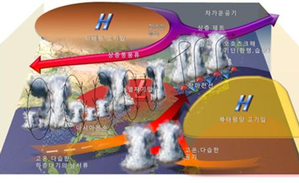
First, LLJ can strengthen rain front. As you can see, when upper cold and dry air from tibet anti-cyclone and warm and moist air from north pacific high meet together, Air becomes unstable. so heavy rain start.
In this way LLJ takes warm and moist air southwestly like north pacific high. So, It strength rain front.

When Rusa occurred, southeasterly to easterly warm and moist flows predominated over the east coast of the central part of the peninsula. And it was caused mainly by the outer circulation of Rusa.
So, in this way advection of warm and moist occurred from sea to land.
Also, before typhoon came to east coast, Northeasterly cold and moist low-level jet blowing from the edge of the North Pacific High, converged in the same area.
So, LLJ resulted in a strong moisture convergence in the coastal area by strengthening the typhoon and growth of unstable air over the central ES near the coast.
Also, potential instability developed by typhoon and low-level jet conveyed the orographic lifting,
Thus it trigger deep convection.
And Upper-jet stream make divergence of lifted air